Project Locations
The Lützow-Holm Bay – Mizuho Plateau region, East Antarctica
The first field observation started on September 1996 at Padda Island (PAD). The seismometer was put in a detached place and covered with a wooden box and a vinyl sheet. From north to south along the Soya Coast, the station codes are as follows; Tottuki Point (TOT), Langhovde area (LNG), Skarvsnes area (SKV), Skallen area (SKL), Padda Is. (PAD) and Strandnebba (STR). Soya Coast is corresponding to the granulite facies of metamorphic gneiss in surface geology and a maximum thermal axis in the metamorphism in 500 Ma lies in the southern area of the Coast between SKL and STR by the petorological studies (Motoyoshi et al., 1989).
At present in 2006 austral wintering season (before IPY), three field stations (TOT, LNG, SKV, and SKL) have been continued to recording as a monitoring station.
![]()
Sites occupied before IPY ( - 2006)
|
SITE NAME |
LATITUDE |
LONGITUDE |
CONDITION |
DATA TYPES |
NEW? / UPGRADED? / PRE-IPY? |
CONTINUOUS DATA? OR, TIME PERIOD OCCUPATION |
|
TOT / JARE - GARNET* |
-68.9112 |
39.8194 |
bed rock |
WIN |
PRE-IPY, continued |
CONTINUOUS DATA |
|
LNG / JARE - GARNET** |
-69.2428 |
39.7147 |
bed rock |
WIN |
PRE-IPY, continued |
CONTINUOUS DATA |
|
SKV / JARE - GARNET*** |
-69.4738 |
39.6071 |
bed rock |
WIN |
PRE-IPY, continued |
CONTINUOUS DATA |
|
SKL / JARE - GARNET**** |
-69.6710 |
39.3988 |
bed rock |
WIN |
PRE-IPY, continued |
CONTINUOUS DATA |
|
AKR / JARE - GARNET# |
-68.4583 |
41.4417 |
bed rock |
WIN |
temporary, finished |
CONTINUOUS DATA |
|
OKW / JARE - GARNET## |
-68.7167 |
40.8350 |
bed rock |
WIN |
temporary, finished |
CONTINUOUS DATA |
|
PAD / JARE - GARNET### |
-69.9200 |
38.3900 |
bed rock |
WIN |
temporary, finished |
CONTINUOUS DATA |
|
STR / JARE - GARNET#### |
-69.9700 |
38.8200 |
bed rock |
WIN |
temporary, finished |
CONTINUOUS DATA |
|
TNH / JARE - GARNET##### |
-67.0883 |
50.2567 |
bed rock |
WIN |
temporary, finished |
CONTINUOUS DATA |
[ location map of Pre-IPY JARE-GARNET station (gif; 13kb) ]
[ relation map between IPY_POLENET / AGAP-GAMSEIS / JARE-GARNET (pdf; 2,395kb) ]
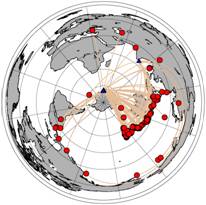
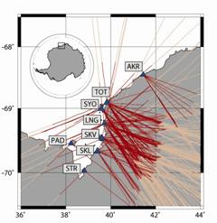
Example of ray path distribution from teleseismic events to the GARNET stations (courtesy of Y.Usui)
[Location] [Obs. Period (detail information)] [LAT(S)] [LON(E)]
*TOT; Tottuki Pt. /a 1997.02.04 - 1997.05.27,1997.07.17 - 1997.10.07 68° 54.6’ 38° 49.8’
*TOT; Tottuki Pt. / b 1998.02.11 - (continued) 68° 54.7’ 39° 49.7’
**LNG; Langhovde/Fukuro Cove 1997.01.28 - 1998.06.02, 1997.08.05 - 1997.12.18 69° 11.4’ 39° 38.4’
**LNG; Langhovde/Yukidori 1997.12.19 - (continued) 69° 14.6’ 39° 42.8’
***SKV; Skarvsnes/Kizahashi Bearch 1997.12.22 - (continued) 69° 28.4’ 39° 36.4’
****SKL; Skallen/Oike-N 1996.12.29 - 1997.01.28 69° 40.2’ 39° 24.6’
****SKL; Skallen/Oike-W 1997.10.13 - (continued) 69° 40.4’ 39° 24.5’
#AKR; Akarui-Misaki 1999.12.22 - 2000.02.12, 2002.01.02 - 2002.01.27 68° 27.5’ 41° 26.5’
##OKW; Okuiwa 1999.12.23 - 2000.02.11, 2002.01.04 - 2002.01.14 68° 43.0’ 40° 50.1’
###PAD; Padda Is. 1996.09.08 - 1996.12.28 69° 55.2’ 38° 23.4’
####STR; Strandnebba 1996.12.28 - 1997.01.28 69° 58.2’ 38° 49.2’
#####TNH; Tonah Island 2000.02.22 - 2000.06.25, 2000.12.21 - 2001.02.20, 2001.08.29 - 2001.08.29 67° 05.3’ 50° 15.4’
![]()
![[ location map of Pre-IPY JARE-GARNET station (gif; 13kb) ]](station_map.GIF)