Background;
Deep seismic exploration have been conducting around the at Magadan Kolymsoe region, Far East, Russia, from 2001 summer season to investigate the crustal structure and conversion tectonics of Kolymsoe pratform - Chukotsk Peninsula. The total seismic profiles are planning to be extended about 2,000 km in length, divided into several short-sections of the profiles operated in a few years of summer seasons.
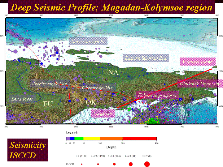
Southern end of the profile start at the margin of Okhotsk Sea (Magadan), extend into Kolymsoe pratform, Chukotsk Mountains, Chukotsk Sea, then terminate at the Wrangel Island. The profile crossed the plate boundary between Okhotsk Plate (south) and North America Plate (north). In the western part of this Peninsula, there is a triple junction between the Eurasia Plate and the above two plates. In southern portion of the profile, the Okhotsk Plate is undergoing deformation as it is compressed as a result of the convergence of North American and Eurasian plates. On the other hand, northern plate boundary between North American and Eurasian plates has an extensional activity to be caused the proposed Moma rift system, along with the Kolyma River basin.
Scientific Targets;
The scientific purpose of the exploration is to define the present crustal velocity structure in order to have a better understanding of the formation of Kolymsoe pratform - Chukotsk Peninsula region chiefly formed in Mesozoic age. One of the main targets is to find the ‘crustal roots’ of the complicated system in geological terrains and micro-continents. In this area, Mesozoic collision structures (not only mountain area) are disposed. In the upper mantle beneath the Chukotsk Peninsula, moreover, remnant subducted slabs of the ancient Kula plate (Northern past plate adjacent to Pacific Plate) are suggested by local seismic tomography (Gorbatov, 2004).
From the report of RAS regional network, high seismicity around
southern part of the profile (i.e., Chersky seismic belt) within the
Okhotsk Plate was observed. Lithospehric deformation and compression
have formed a convergence of North American and Eurasian plates to
originate the relatively high seismicity (Mackey, et al., 1998).
Crustal thickness derived from travel-time inversion using local
natural events has a variation in 36-40 km in southern half of the
profile (Mackey, et al., 1998). Accordingly, it is also significant
to define the precise crustal structure of the Chukotsk area,
associated with hypocentral distribution and origin of local
seismicity.
Observations;
The observation system consists of triggered recording data-loggers as independent stations (number of 20-30, by Geophysical Survey of RAS, Nobosibirsk) with short period seismometers. Some parts of the stations used multi-channel geophones to get coherent signals by staking waves. In the next survey, moreover, we are planning to increase the number of stations (20-100) by joining the other type of 16bit data-logger prepared from NIPR. The seismic signals were originated from a total of six tons of dynamite explosive shots at both end of the profile, combined with several shot points by vibrator cars (40 tons of weight) in the middle of each survey line.
In 2001 and 2004 summers, profiles of 800 km and 300 km in length were conducted, respectively. To obtain a whole imaging of the crustal section, remained portion of the profiles are planned in near future.